







Representing a sphere on a plane is a pure geometry problem that humanity has been trying to solve for more than 2,000 years. A flat map can faithfully show one or several properties of the territory, such as distance, shape, or direction, but never all at once. There will always be some type of distortion, and in the case of the recent UN resolution, the Mercator problem – the projection used in schools, textbooks, international organizations, and even in our GPS – lies in the size of the continents.
Read more Zohran Mamdani: “Democracy is useless if people cannot meet their needs”
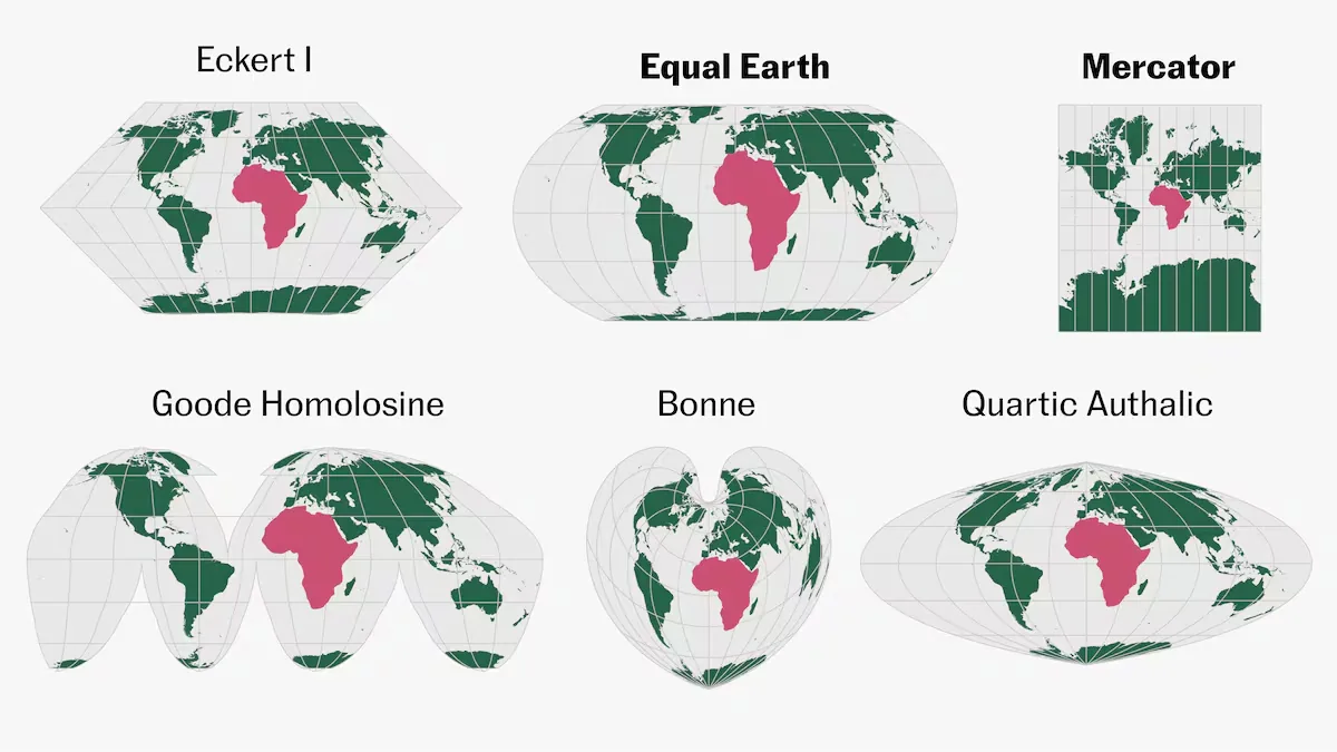
The Mercator projection, invented in the 16th century for navigation, perfectly respects the real direction. With this map, four centuries ago it was possible to cross the ocean using only a compass, hence its success. On the other hand, Mercator sacrifices size proportions, exaggerating the areas closest to the poles. Others, however, respect size but distort shapes. If we follow Africa across several projections, we can compare its size and shape relative to the other continents.
To go from a spherical shape to a plane, there are three main groups or techniques. One of them is projecting the globe onto a cylinder, the method used by the Mercator projection. Projections of this type can represent the world in a single rectangle, without cuts, and with minimal distortions near the equator. On the other hand, distortion is extreme at the poles.
Another alternative is projecting the globe onto a cone. This method exaggerates shapes farther from the center, so it is not suitable for visualizing the entire globe. However, these projections are ideal for representing east-west extended areas. The third option is projecting the world onto a plane, where the strong point is that directions from the central point are exact toward any other point on the map, but shape is sacrificed.
Each world map is a trade-off between one property or another. The choice of the correct projection depends on the region to be represented and the message to be communicated. And it is an important decision. Maps are not simple representations of places; they carry social loads that “influence how we conceive the importance, centrality, or peripheral position of those places,” as stated by Derek Alderman, a geographer at the University of Tennessee in Knoxville.
“A map is not just a map”
The use of Mercator worldwide for nearly 450 years is what led the UN, in a historic vote led by Togo and supported by the African Union (AU), to change the recommended projection from Mercator to “one that more accurately represents the size of the continents,” such as Equal Earth. The latter, designed in 2018 by cartographers Bojan Šavrič, Tom Patterson, and Bernhard Jenny, uses a mathematical formula that preserves the relative areas of territories, although at the cost of distorting their shapes and distances.
“It may seem just a map, but it really isn’t,” Selma Malika Haddadi, vice president of the AU Commission, told Reuters. According to the African Union, the Mercator projection fosters the false impression that Africa is “marginal,” despite being the second largest continent in the world by area and having more than 1 billion inhabitants. This perception has been perpetuated in the media, education, and in the development and application of public policies for a long time, the union argues.
The proponents of the resolution describe it as “a historic milestone toward global cartographic equity.” The text, which is non-binding, does not advocate banning the Mercator projection or replacing it in areas such as air or maritime navigation. Its goal is to advance toward a more equitable cartographic representation of the world.
The United States was the only country in the UN Assembly to vote against the recommended projection change. In a later statement, its representative said the resolution was “superfluous.” Either way, the Equal Earth projection reduces the size of countries in the northern hemisphere such as the United States, Greenland, or Russia, a change the African Union has pursued since August 2025. The entity Correct The Map, one of the initiative’s promoters, asks: “If we have been wrong for so long about something as basic as the size of Africa, what other things about the continent have we simply accepted without questioning?”