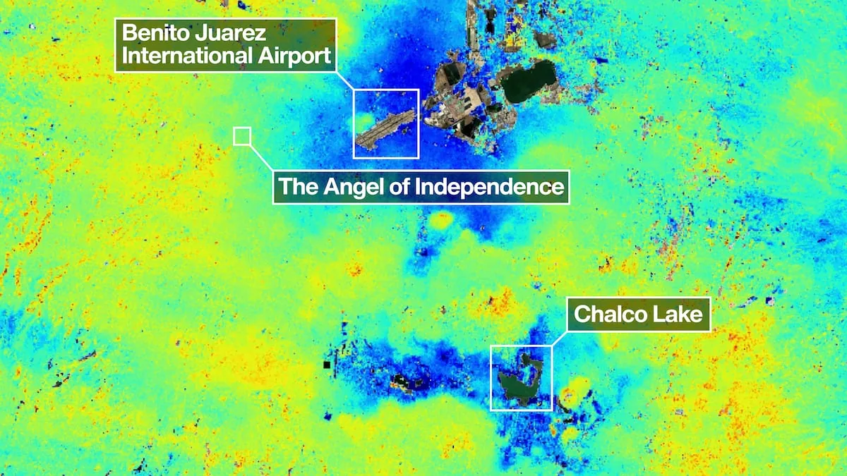









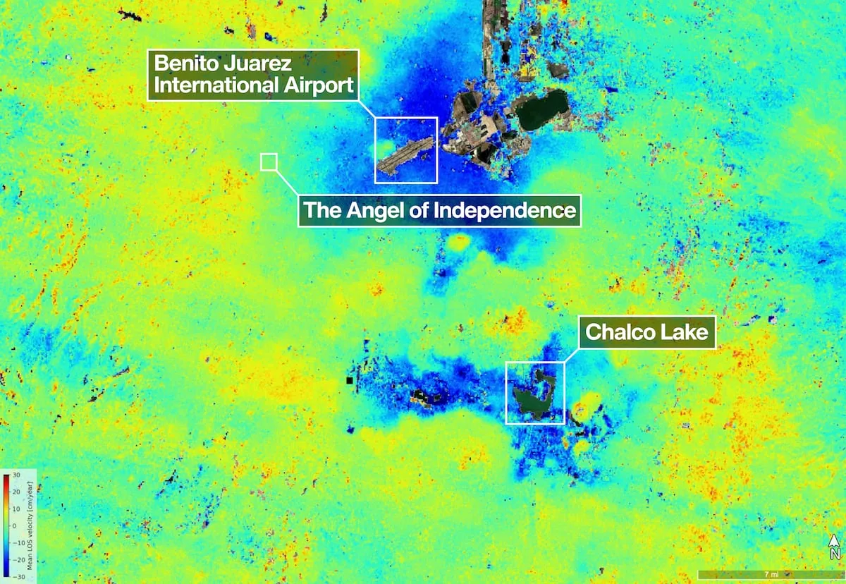
Mexico City is sinking faster than previously thought, and for the first time NASA observes it from space with unprecedented clarity. One of the most powerful radar systems launched so far has mapped how the ground moves beneath one of the fastest sinking capitals in the world, the Mexican one. The new images, taken by the NISAR satellite between October last year and January 2026, show not only the rate of sinking but also how fast and precise monitoring of changes on the Earth’s surface from orbit can be, without clouds or vegetation interfering with the measurements.
NISAR (NASA–ISRO Synthetic Aperture Radar) is a synthetic aperture radar satellite jointly developed by NASA and the Indian Space Agency (ISRO). It was launched in July 2025 and is designed to fly over the Earth day and night, in rain or sun, and capture even very subtle movements of the surface.
The satellite carries two synthetic aperture radars at different wavelengths: the L-band radar, provided by NASA, and the S-band, by ISRO. Its reflector antenna, cylindrical in shape and 12 meters wide, is the largest radar reflector NASA has sent to space. Thanks to this, NISAR “sees” ground movement with an accuracy of just millimeters per day, something optical cameras and many other radars cannot achieve.
A century of documented sinking
The Mexico Valley Metropolitan Area, home to more than 20 million people, was built over a vanished aquifer and the bed of ancient lakes. The massive extraction of groundwater, combined with the weight of urban infrastructure, has slowly compressed the sediments of the ancient lake for more than a century.
As early as 1925, engineer Roberto Gayol had documented the problem, and by the 1990s and 2000s, parts of the city were sinking about 35 centimeters per year, damaging Metro tunnels, pipes, and buildings. Different generations of radar satellites have continued to record this movement, but NISAR takes these observations to another level, with more detailed and updated maps.
The new NISAR analysis is based on preliminary measurements taken during the city’s dry season. In the resulting map, the areas sinking fastest appear in dark blue, where the descent exceeds two centimeters per month. The areas in yellow and red tones are interpreted as background signal or system “noise,” which is expected to decrease as the satellite accumulates more observations.
In the center of the image, Benito Juárez International Airport can be seen, while to the northeast is Lake Nabor Carrillo, a body of water distinguished as an elongated dark green spot. These data clearly identify which areas are sinking faster and help anticipate possible damage to airports, roads, drainage, and water networks.
A monument as a sinking thermometer
One of the most visible symbols of the sinking is the Angel of Independence, the Reforma monument inaugurated in 1910 to celebrate the first centenary of Mexico’s independence. The building is about 36 meters tall and, over the years, the ground around it has sunk so much that 14 steps had to be added at its base: tangible proof of ground movement that satellites like NISAR can now quantify with figures and maps. “Images like this confirm that NISAR’s measurements match what was expected,” explained Craig Ferguson, deputy project director at NASA headquarters in Washington, highlighting that the L-band radar wavelength will allow detecting sinking even in densely vegetated coastal areas, where rising sea levels and subsidence combine. The latter phenomenon consists of the slow and progressive lowering of ground level over large areas, caused by natural processes or human activities such as overexploitation of aquifers and sediment compaction.
“Mexico City is a known hotspot for subsidence, and this type of image is just the beginning for NISAR,” said David Bekaert, mission manager at the Flemish Institute for Technological Research and a member of the satellite’s scientific team. The radar will not only be used to monitor the Mexican capital but also moving glaciers, landslides, changes in crops, and other transformations of the Earth’s surface worldwide. Moreover, it will reshape groundwater management policies, infrastructure design, and long-term urban planning.
Subscribe to EL PAÍS Mexico’s newsletter and the WhatsApp channel to receive all the key news about this country.