








The Iranian blockade of the Strait of Hormuz has dealt a severe blow to the global economy, exacerbated by the blockade on the blockade imposed by the United States. Tehran’s announcement to reopen the strait, only to declare its closure again the next day, and the US boarding of an Iranian-flagged cargo ship this Sunday have added confusion and tension to the situation.
Read more Barcelona warning
But how do these naval blockades work? And why do some ships pass and others don’t?
Two points 500 kilometers apart
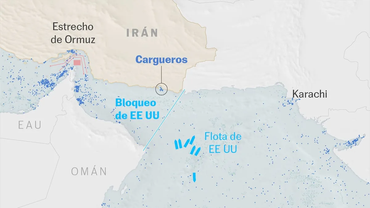
The first important piece of information to understand how these naval blockades work is to realize that they are located at two very distant points: the Iranian one is in the Strait of Hormuz itself, which connects the Gulf of Oman and the Persian Gulf and whose minimum width is just over 30 kilometers; the American one is located at the passage from the Gulf of Oman to the Indian Ocean, about 500 kilometers further east. Or, in other words, there is a distance between them similar to that between the Strait of Gibraltar and Cartagena.
Blockade in Hormuz
Source: US Department of Defense, Marine Traffic. EL PAÍS
A closure that isn’t one
The second essential fact is that in neither case is it a complete closure of these maritime routes, but rather a severe restriction of their use. However, given that the value of both the vessels transiting these maritime routes and the cargo they carry amounts to tens of millions of euros, and naval trade involves numerous layers of contracting (shipowner, shipping company, cargo contractor, freight and vessel insurer…), the mere possibility of the use of force at any of these points has almost paralyzed transport.
The result is that, of the 120 to 150 ships that crossed Hormuz daily in both directions before the conflict, the number has dropped to around a dozen. And about 2,000 ships, with their crews, have been trapped in the Gulf of Oman and the Persian Gulf.

The two routes imposed by Iran
The United Nations Convention on the Law of the Sea (UNCLOS) provides for free commercial navigation through international maritime straits such as Hormuz or Gibraltar, which “shall not be impeded” by coastal states. However, the United States has not signed this convention, and Iran, although it has, has not ratified it.
Even so, the Islamic Republic relies on certain provisions of the convention in case of armed conflict, claiming that it is allowing the free passage of vessels as long as they are not vessels “linked to adversary [states]”.
To control passage, it has established an alternative route to that used in peacetime — an exit and an entry corridor that transit through the Omani waters of the strait — alleging the risk of naval mines in that area (placed by Iran). The route established by Iran passes next to Qeshm Island and Larak Island, from where the Revolutionary Guard supposedly monitors and authorizes passage. Some reports indicate that certain ships have been forced to pay a toll of up to one million dollars, which contravenes UNCLOS.
Routes and mined area marked by Iran
Source: Marine Traffic. EL PAÍS
The US blockade, on the other hand, extends in a line that, from north to south, covers about 300 kilometers. To provide coverage for such an extension, it has deployed a dozen military vessels, including the aircraft carrier USS Abraham Lincoln, and numerous aerial assets, including fighters, helicopters, and reconnaissance planes.
In this case, the closure is also not total, and according to statements by US authorities, it is directed exclusively at vessels coming from or heading to Iranian ports, although last week, the US Chief of Staff, Dan Caine, warned ghost ships and those violating international navigation regulations in the blockade zone that they also risk boarding. In its latest update, the Central Command of the Armed Forces stated that 27 vessels have turned back due to US warnings in its blockade zone. This Sunday, the Touska, an Iranian-flagged container ship from Malaysia heading to the port of Bandar Abbas (Iran), was boarded by US forces before entering the Gulf of Oman for refusing to obey blockade instructions, as explained by Central Command.
Tricks to bypass the blockade
Although US forces claim that no vessel has bypassed their blockade, maritime intelligence companies maintain that some vessels linked to trade with Iran, including supertankers, have indeed overcome the cordon. To do this, they use various irregular tactics and diversionary maneuvers such as spoofing — which consists of altering the information transmitted to the Automatic Identification System (AIS) — turning off the AIS signal, or manipulating it to indicate different entry and exit ports. The Windward platform has also detected ship-to-ship crude oil transfers as a method to circumvent the double cordon: vessels that can cross Hormuz from the Persian Gulf transfer their cargo in the Gulf of Oman to other vessels not sanctioned by the United States and can sail beyond the Indian Ocean.
Read more The irresponsibility of the angry voter