










The episode of extreme temperatures that has affected much of Spain this week, peaking in the Valencian Community, where 44° was reached this Wednesday and record-breaking infernal nights were experienced, gave way this Thursday within hours to severe storms, accompanied by very strong gusts of wind and hail as a final touch. The showers are especially violent in the Valencian Community, with a trail of material damage, traffic disruptions, and 50 fire brigade call-outs just in Valencia, although they are also affecting other areas of the southeast such as Murcia and Albacete. At dawn, the storms will head to the Balearic Islands.
In the Valencian Community, the Spanish Meteorological Agency (Aemet) had issued an orange alert ―the second level on a three-level scale― for storms, which have been occurring since two in the afternoon in several municipalities of Valencia, with several wet microbursts, the most impressive in Alzira, where it caused material damage. “It is one of the most intense microbursts recorded in Spain, it had the power of a tornado,” according to Meteored meteorologist Samiel Biener. A microburst is a very strong air current descending from a storm, hitting the ground like a strong slap and rapidly spreading in all directions. It can generate very intense wind gusts and cause damage similar to that of a tornado, although in this case the air rotates around a vortex.
“A series of intense storms are forming in the southeastern peninsula, on the leading edge of the trough crossing the Mediterranean, advancing from the Region of Murcia and Albacete to the province of Valencia. The first to arrive, after midday, had a certain degree of organization and has left very intense showers in the Valencia riverbanks,” Biener, also a climate researcher at the University of Alicante, described to this newspaper early in the afternoon.
But, in his opinion, the most notable has been “the wet microburst associated with this storm cell, with peaks of more than 140 kilometers per hour in some observatories in Sumacàrcer and Alzira,” according to data from the Valencian Meteorology Association (Avamet). “It is one of the most intense microbursts measured in Spain since records began, with an intensity similar to an EF1 tornado, causing scenes of panic among drivers and people surprised by the phenomenon, with significant material damage,” adds the expert.
The reason these storms are so violent lies in “the Mediterranean’s fuel”: “The supply of very warm and humid air from the sea may have made this storm more virulent.” Additionally, atmospheric conditions are very conducive to the formation of microbursts in other areas of the east and southeast this Thursday,” concludes the Meteored meteorologist.
The Aemet delegation in the Valencian Community has explained on social media that the storm south of Valencia moved out to sea near Cullera, El Perelló, and El Saler. As it passed through these areas, very violent phenomena occurred, such as very strong wind gusts. In the Region of Murcia, the state agency also warns, new storm cells are emerging that will affect the Valencian Community in the coming hours. “There is now a train of cells inland, heading to the coast passing again through the Valencian Community,” warned José Luis Camacho, Aemet spokesperson.
🔴 Violent storm in l’Alcúdia (Valencia) with hail, torrential rain, and severe wind gusts.
— ValènciaWeather⚡️ (@Valencia_WX) August 20, 2026
📹 Courtesy of @Carlosm_pe (Media: contact the author for usage rights). pic.twitter.com/c89sRo2UjT
The wet microbursts, seen in several towns in the Valencian regions of Canal de Navarrés and Ribera (Alta and Baja), have left gusts of nearly 149 kilometers. After two in the afternoon this Thursday, personnel from the Provincial Fire Consortium of Valencia attended about ten incidents caused by the episode of rain, storms, and strong wind in La Ribera, in towns such as Alzira, Massalavés, Benimuslem, and Algemesí. The episode lasted barely 30 minutes but was intense. Air traffic controllers have warned of flight delays in areas affected by the storms for safety reasons.
In Carxaixent, the first storm, accompanied by strong winds, lasted about 20 minutes. Its mayor, Carol Almiñana, describes the episode as “tremendous.” “It caused a lot of damage, with fallen trees and facade detachments. It’s a disaster,” she notes while explaining the race-against-time work of many municipal personnel to remove branches and debris blocking some streets. Another strong storm, this time of rain, forced them to stop the work. “We are worried because there are many elements to secure due to the risk of detachment,” she added, while urging the population to be cautious and stay indoors because the episode may last several more hours. In Cullera, one person was injured on a beach when an umbrella blown by the strong wind hit them on the head.
Aemet has detailed that the accumulated rainfall is not significant but has urged caution due to the wind, especially on fragile or poorly anchored structures. At the Polinyà de Xúquer station, accumulated precipitation is 33.4 liters per square meter, with a maximum of 14.1 liters in 10 minutes and wind gusts of 94 kilometers per hour. Additionally, the temperature drop has been 19 degrees; from 37.7 to 18.1, according to Aemet.
⛈️ Very intense precipitation, sometimes accompanied by hail, with very strong wind gusts affecting municipalities such as Alzira, Riola, and Algemesí
— VOST Comunitat Valenciana (@VOSTcvalenciana) August 20, 2026
📸 13:45h #Meteo #FMA @AEMET_CValencia maintains its orange alerts in these areas for rain and storms 🟠 pic.twitter.com/M8e3YfPwKy
The passage of storms and wind gusts caused the collapse of the roof of the Santa Catalina church in Alzira, the fall of trees, road closures, and other damage in the town. One of the trees knocked down by the strong gusts fell onto the C2 commuter train line and interrupted rail traffic. It also affected medium and long-distance trains, and circulation was interrupted for a time on Metrovalencia’s L1 line between l’Alcúdia and Castelló.
A lightning strike in the municipality of Tavernes de Valldigna triggered a fire, with two aerial units, two forest fire brigades, and a helitranported brigade working on its extinction. The Valencian Government has recommended extreme caution due to the episode of rain and storms forecast for the southern coast and interior of Valencia and the interior of Alicante.
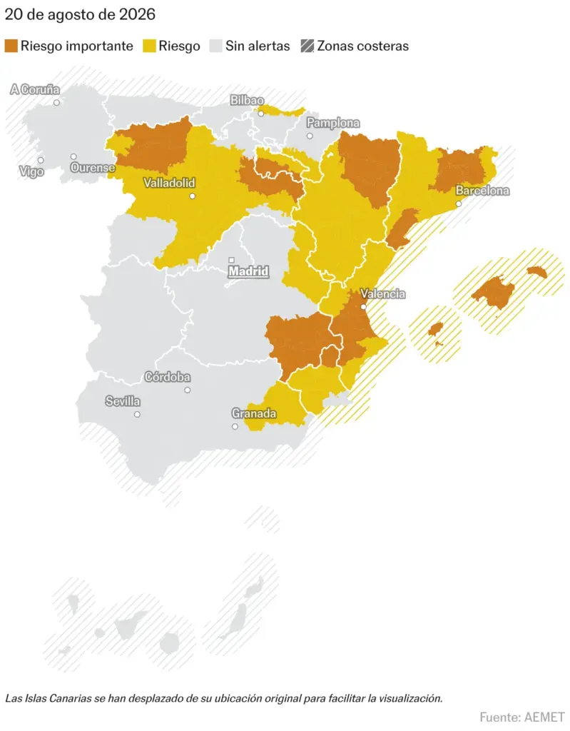
In addition to the Valencian Community, intense storms are also affecting other areas of the southeast such as Murcia and Albacete, where there is also an orange alert, as well as the Balearic Islands, Catalonia, Castilla y León, La Rioja, and Aragón. Of lesser intensity, yellow alert, there are showers in Andalusia, Navarra, and the Basque Country. In total, there are alerts in 11 communities. Among the main incidents, a downpour has left hail and flooded streets in the Murcian towns of Jumilla () and Yecla, as well as in Hellín, Pozohondo, Tobarra, and Pozo Cañada (Albacete). In Palma, the City Council has canceled the El Combo Batanga concert scheduled for this Thursday due to the rain.
After a complicated afternoon, strong or very strong storms are expected in the Balearic Islands at dawn, especially in Mallorca and Menorca. According to Aemet, very strong or even hurricane-force wind gusts could occur there.
Storms in the interior southeast of the Iberian Peninsula! This afternoon (08/20/2026), this is how it poured in Jumilla (Murcia), turning the streets into rivers in minutes. Video: @JuanjoPerez_16. pic.twitter.com/9SwEf9V8lR
— MeteOrihuela (@MeteOrihuela) August 20, 2026